

Not all school districts are alike when it comes to their fleet routing and planning processes. Districts have either large or smaller fleets, and many still use manual, cumbersome systems to tackle some of the most challenging aspects of their jobs.
GIS technology can bring value to every aspect of our transportation operations including routing, student location, student accountability, parent notification, field trip planning and more.
School districts don’t have to bite off more than they can chew. GIS technology can be implemented in every school district at a pace that meets each district’s needs.
Revolutionizing School Transportation with Modern GIS Solutions
Budgets are tight everywhere, driver shortages are a nation-wide concern, and vehicle maintenance and downtime can be seriously problematic for any district. Cutting wasted effort and inefficient processes is an absolute necessity and modern GIS systems can help you do just that.
How would knowing which of your routes are optimized, and which aren’t, help your operations?
How would having access to real-time data help you improve parent/school communications?
And how would being able to re-route with ease, while factoring in road usage/rules, help you better protect your students on their way to school?
Let’s look at what this might look like for a school district with the options that are currently available.
Streamline Operations with All-in-One Solutions
All-in-One Solutions enable the user to query several databases depending on the desired outcome. These systems feature an interactive geographic mapping system that graphically displays database queries, tracks vehicles and students in real-time and provides a live view on-board a bus during critical events. GIS technology can shave days, even weeks from planning efforts, reducing it to a matter of hours.
Using an all-in-one solution, transportation departments can produce ‘what if’ scenarios, plan next year’s routing without disturbing the current year’s plans, and respond to urgent situations better and faster.
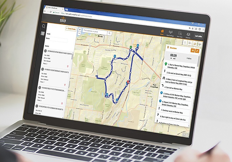
Safe Fleet® Compass™ is an all-in-one esri-based, routing and planning system that delivers routing, vehicle tracking, video surveillance and vehicle status in a single interface. A transportation department can view planned vs. actual routes in real-time, integrate with existing student information databases, optimize route and student assignments, and provide full audit trails.
Scaling Up: Meeting the Needs of Larger Districts
Comprehensive routing and planning systems for large districts are complex, take time to implement, require more involved training to use, and require more budget. Some transportation departments want and need these sophisticated systems, but for budgeting purposes, they need to phase their implementations into manageable pieces. Compass can be implemented in two phases:
Automated Routing and GPS Tracking
Compass routing can connect to tracking systems already installed on fleet vehicles. This integration provides time, location, direction, and vehicle speed data in 20-30-second intervals. Depending on the equipment and sensors installed on the fleet, the information displayed could also include stop arm extension, signal light, door opening and video recording status. When this information is overlaid with mapped route plans, a fleet management team can instantly see deviations and address them accordingly. Districts that use GIS-based routing systems can realize ROI almost as soon as they start using this type of routing system.
Student Tracking and Viewing
This functionality adds an additional safety layer to the systems you are already using to protect students while they are in your care. If a bus breaks down, or the unthinkable happens, you’ll have virtual eyes on the situation immediately. With Safe Fleet Student Ridership Tracking, you’ll know where the incident occurred, you’ll know what happened, and you’ll know who has been impacted. Knowing if a student is on a bus, where they got on or off the bus, if they missed the bus and never got on it, as well as information on everyone else on the bus in the event of an emergency, is invaluable and cannot be measured in dollars.
Empowering Smaller Districts
Not all transportation departments want or need an all-in-one solution. While others may want an all-in-one, but don’t have the budget or resources to implement all at once. School districts have choices. They can implement an all-in-one system in manageable pieces, or select a simpler, easy-to-use planning tool.
Safe Fleet Path captures route maps from vehicle GPS and student tracking data. Within days of implementing the system, a transportation department can begin to realize route efficiencies, access accurate driver directions, and reduce parent concerns by providing accurate school bus arrival and departure times.
School districts can even pair Safe Fleet Path with a student accountability mobile app that automatically notifies parents when their children get on and off the bus.
The benefits of GIS data can be experienced in our daily lives in many ways, and that includes school transportation departments. Knowing exactly what to do and who to contact in real-time can make a huge impact on final outcomes. This can truly mean the difference between life and death.
Kerry Somerville is senior product manager for Safe Fleet. Contact us to learn more. We’ll steer you in the right direction. Visit www.SafeFleet.net for more information